Variable Rate Drone Spraying Explained: From Field Map to Flight Plan


Variable rate drone spraying is one of the most practical ways to connect precision agriculture data with real field action.
The idea is simple: not every part of a field needs the same treatment. Some zones may have heavier pest pressure, denser canopy, wetter ground, weaker crop growth, or different disease risk. Variable rate spraying uses field data to adjust the application plan instead of treating every acre the same way.
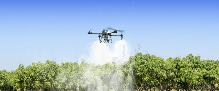
For drone operators, the opportunity is clear. Agricultural drones are flexible, fast to deploy, and well suited for fragmented fields, orchards, rice paddies, vegetables, and areas that are difficult for ground sprayers to enter. But variable rate drone spraying is not just "flying slower in one place and faster in another." It requires a workflow:
Field data -> management zones -> prescription plan -> flight route -> calibration -> application records
This guide explains how that workflow works and what farm managers should check before using variable rate spraying with agricultural drones.
Important note: Variable-rate capability depends on the drone platform, controller, software, file compatibility, pump and flow control, local regulations, and pesticide labels. Always verify system compatibility before promising prescription-map execution to customers.
What Is Variable Rate Drone Spraying?
Variable rate drone spraying is the practice of adjusting spray application based on spatial variability within a field or crop block.
Instead of one uniform rate across the entire field, the operator uses field data to decide where different application settings may be needed. Depending on equipment and agronomic goals, the adjustment may involve:
- Application volume
- Flight speed
- Spray width
- Droplet setting
- Flight height
- Number of passes
- Targeted spot spraying
- Separate treatment zones
The University of Florida IFAS Extension describes variable rate technology as a way for growers and advisors to apply inputs such as water, nutrients, and chemicals at different rates in response to spatial variability. USDA ERS similarly notes that farmers use variable rate technologies to control how much seed, fertilizer, and chemicals are applied as machinery moves across a field.
For drones, variable rate thinking can be used in two ways:
- Map-based variable rate spraying: The operator builds a prescription plan before the flight using maps, scouting data, remote sensing, crop history, or agronomist recommendations.
- Sensor-based variable rate spraying: Sensors detect crop or field conditions in real time and adjust application as the machine moves.
Most drone spraying programs start with map-based planning because it is easier to audit, explain, and repeat.
Why Variable Rate Matters for Drone Spraying
Uniform spraying is simple, but fields are rarely uniform.
Within the same farm, there may be:
- Low and high pest-pressure zones
- Areas with stronger or weaker canopy density
- Wet spots and dry spots
- Field edges with higher weed pressure
- Tree rows with uneven canopy height
- Disease-prone low areas
- Different soil textures
- Irrigation or drainage differences
- Previous treatment failures
If the whole field is treated at one rate, some zones may be over-treated while others remain under-treated. Variable rate planning gives the operator a way to match application effort to field need.
Potential benefits may include:
- Better targeting of problem zones
- Reduced unnecessary input in low-pressure areas
- Better canopy coverage where crop density is high
- More consistent treatment in irregular fields
- Improved records for future decisions
- More professional service reporting
That said, variable rate is not automatically better. It is only useful when the data, prescription, equipment, and agronomic decision are strong enough to justify the added complexity.
The Map-Based Workflow
A practical variable rate drone spraying workflow usually follows seven steps.
Step 1: Build a Reliable Field Map
The field map is the base layer for everything else.
A useful map should include:
- Field boundary
- Crop rows or blocks
- Obstacles
- Sensitive areas
- Water sources
- Roads and access points
- Takeoff and landing zones
- No-spray zones
- Treatment zones
Agricultural drone mapping can help operators define field boundaries, identify obstacles, and prepare routes. EAVISION product pages highlight features such as field mapping, hand-drawn boundaries, route planning, RTK support, and tools for weak-signal or mountain-obstructed environments.
For variable rate work, the map must be accurate enough to connect each treatment zone to the correct location in the field. A beautiful map that is not georeferenced correctly can create a bad spray plan.
Step 2: Gather the Right Data Inputs
Variable rate spraying depends on the quality of the data used to create zones.
Possible data inputs include:
- Drone crop monitoring images
- Satellite imagery
- NDVI or vegetation index maps
- Pest scouting records
- Disease scouting records
- Soil maps
- Yield maps
- Crop stage maps
- Plant population maps
- Canopy density observations
- Irrigation and drainage maps
- Farm manager notes
- Previous application records
Not all data has equal value. A recent field scouting map may be more useful for insect control than an old yield map. A canopy density map may be more useful for orchard spray volume than a soil fertility map. The data source should match the treatment goal.
Ask one question before building a prescription:
Does this data explain why one part of the field should receive a different spray plan than another?
If the answer is no, the prescription may be false precision.
Step 3: Create Management Zones
Management zones are areas of the field that should be treated similarly.
For drone spraying, zones might be based on:
- Low, medium, and high pest pressure
- Thin, medium, and dense canopy
- Field edge vs field center
- Wet area vs normal area
- Sensitive crop boundary
- Different varieties or planting dates
- Orchard blocks with different tree height
Keep zones practical. A map with too many tiny zones may look impressive but be difficult to fly, calibrate, verify, and explain to a customer.
For many farm operations, three to five zones are enough:
- No treatment
- Low rate
- Standard rate
- High attention zone
- Buffer or sensitive area
The goal is to turn field variability into a flight plan the operator can safely execute.
Step 4: Convert Zones Into Spray Decisions
A management zone is not yet a spray plan. It must be translated into application decisions.
Depending on the product label, crop, drone system, and agronomic recommendation, the operator may adjust:
- Spray volume per hectare or acre
- Droplet size
- Flight speed
- Flight height
- Spray width
- Number of passes
- Route overlap
- Tank mix sequence
- Area to skip or spot spray
This step should involve an agronomist, crop consultant, or qualified applicator where appropriate. The pesticide label remains the controlling document. A variable rate plan must still stay within labeled rates, timing, crop stage, buffer restrictions, and environmental conditions.
For drones, one of the most practical approaches is zone-based application. Instead of expecting the drone to change every parameter continuously, the operator may create separate flight tasks or route blocks for different zones.
That can make the job easier to audit:
- Zone A: no treatment
- Zone B: standard application
- Zone C: higher spray volume for dense canopy
- Zone D: edge treatment with drift controls
Step 5: Check Equipment Compatibility
This is where many variable rate plans fail.
Before promising a variable rate drone spraying service, confirm:
- Can the controller or software import prescription maps?
- Which file formats are supported?
- Can the drone adjust flow rate during flight?
- Can the operator safely divide the job into zone-based tasks?
- Can pump output, speed, and spray width be calibrated accurately?
- Can the system record where it sprayed and at what settings?
- Can maps and records be exported for customers?
- Does the system support RTK or accurate positioning where needed?
If automatic prescription-map execution is not available, the operator may still use variable rate thinking by dividing the field into separate planned zones and applying calibrated settings to each zone. That is not the same as fully automated variable rate control, but it can still improve planning and documentation.
The key is transparency. Tell customers exactly what the system can and cannot do.
Step 6: Calibrate Before the Job
Calibration turns the prescription into reality.
For drone spraying, the core relationship is:
Application volume = flow rate / ground coverage rate
In practical terms, the operator must align:
- Tank mix concentration
- Flow rate
- Flight speed
- Spray width
- Flight height
- Droplet size
- Route overlap
A simple flow-rate formula is:
Required flow (L/min) = Application volume (L/ha) x speed (m/s) x spray width (m) x 0.006
If the drone changes speed or spray width without changing flow rate, the actual application volume changes. If the prescription changes the desired volume but the equipment cannot match it, the variable rate plan is only theoretical.
Calibration should be documented for each zone or rate group.
Step 7: Verify and Record the Application
After spraying, the operator should produce a job record.
Useful records include:
- Field boundary
- Treatment zones
- Route map
- Product and rate
- Application volume
- Flight speed
- Spray width
- Droplet setting
- Weather conditions
- Start and end time
- Acres or hectares treated
- Skipped zones
- Any route pauses or changes
- Customer notes
Records are valuable for compliance, customer trust, and future decisions. They also help the operator compare planned vs actual performance.
Variable rate spraying should become a learning loop:
Plan -> apply -> record -> scout -> compare -> improve next prescription
Where Variable Rate Drone Spraying Pays Off
Variable rate drone spraying is most useful when variability is real and actionable.
Good candidates include:
- Orchards with uneven canopy density
- Vegetables with patchy pest pressure
- Rice paddies with wet or inaccessible areas
- Cotton or field crops with localized pressure
- Fragmented fields with irregular shapes
- Farms already using scouting maps or imagery
- Service providers who need better customer reports
- Poor candidates include:
- Fields with uniform pest pressure
- Jobs where the label requires one fixed rate and method
- Farms without reliable maps or scouting data
- Operators without calibration discipline
- Software or equipment that cannot execute or record the plan
Variable rate should solve a real problem. If the field does not justify the extra planning, a well-calibrated uniform application may be the better choice.
Common Mistakes to Avoid
Mistake 1: Treating an NDVI Map as a Spray Prescription
An NDVI or crop vigor map is not automatically a spray map. It may show plant condition, but it does not always explain pest pressure, disease risk, or label-appropriate treatment.
Use imagery as evidence, not as the whole decision.
Mistake 2: Creating Too Many Zones
Overly complex prescriptions are hard to fly and verify. Start with practical zones that operators can explain and execute.
Mistake 3: Ignoring Calibration
A prescription is only useful if flow rate, speed, width, and droplet setting match the plan.
Mistake 4: Forgetting the Label
Variable rate does not override pesticide labels. The label still controls rate, timing, crop, buffer, weather, and safety requirements.
Mistake 5: Selling Automation Before Confirming Compatibility
Before promising automatic variable rate control, verify software, file format, flow control, route planning, and record export.
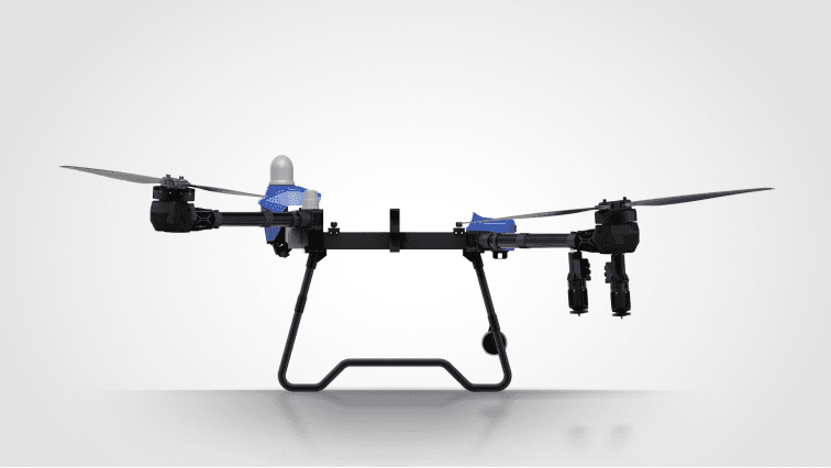
How EAVISION Fits Into the Workflow
EAVISION's agricultural drone ecosystem supports several building blocks that matter for variable-rate-style workflows:
- Field mapping and hand-drawn boundaries
- Intelligent route planning
- RTK positioning support
- Super-Link communication station and surveying tools
- 2K FPV view and route visibility
- Multi-scenario spraying, spreading, lifting, and mapping
- High-capacity spraying platforms such as J150
- Flexible service platforms such as J70
These features can support the planning and execution layers needed for precision spraying. The exact variable rate workflow should be designed around the operator's software, agronomic data, file compatibility, product label, and field conditions.
For a service provider, the strongest value proposition is not "the drone sprays differently everywhere." It is:
We use field data, route planning, calibration, and records to apply more thoughtfully.
That message is easier to defend and easier for customers to understand.
Bottom Line
Variable rate drone spraying connects precision agriculture data with practical field application.
It starts with a simple idea: treat different zones according to their actual need. But the execution requires more than a map. It requires reliable data, clear management zones, a label-compliant prescription, compatible equipment, calibration, and records.
For farm managers, variable rate spraying can improve decision quality. For service providers, it can create a more professional, data-driven offering. For both, the key is to start with real field variability and build a workflow that can be safely repeated.
Do not chase complexity first. Start with good maps, good scouting, practical zones, and accurate calibration. Then let the variable rate workflow mature with each season.
FAQs
What is variable rate drone spraying?
Variable rate drone spraying is the use of field data to adjust spray application by zone or location instead of applying one uniform plan across the entire field. It may involve different spray volumes, speeds, droplet settings, passes, or treatment zones.
Is variable rate spraying the same as spot spraying?
Not exactly. Spot spraying targets specific areas, often where weeds or pests are present. Variable rate spraying may treat larger management zones at different rates or settings based on crop condition, pressure, canopy, or prescription data.
Can every agricultural drone do automatic variable rate spraying?
No. Automatic variable rate spraying depends on the drone, controller, software, file formats, pump control, flow accuracy, and recordkeeping. Operators should verify compatibility before promising prescription-map execution.
Can I use variable rate thinking without automatic prescription maps?
Yes. Operators can divide a field into planned zones and run separate calibrated tasks for each zone. This is not the same as fully automated variable rate control, but it can still improve planning, targeting, and documentation.
Where does variable rate drone spraying pay off most?
It is most useful where field variability is real and actionable, such as orchards with uneven canopy, field edges with weed pressure, disease hotspots, fragmented fields, and farms already using scouting or imagery data.